Exail is a leading high-tech designer and manufacturer of advanced cutting-edge robotics, aerospace, subsea and marine navigation technologies. Exail delivers unrivaled performance, reliability and safety to its civil, defense and maritime clients operating in severe environments.
From subsea to outer space, Exail expands their capabilities with a full range of robust in-house manufactured components and systems, including inertial navigation, acoustic subsea positioning, imaging and autonomy technologies.
Employing a workforce of 1800 people worldwide, the company benefits from a global footprint and conducts its business in over 80 countries. Exail products are ideal for a wide range of unmanned systems used in geoscientific, maritime, defense, and oil and gas applications, including AUVs (autonomous underwater vehicles), ROVs (remotely operated vehicles) and USVs (unmanned surface vessels).
Formed by ECA Group and iXblue joining forces in 2022 Exail is a subsidiary of Exail Technologies, a family-owned company specialized in high-technology.
Solutions for Civil Applications

Exail provides surface and subsea solutions for the oil and gas, offshore energy and geosciences industries. Our inertial navigation sensors, USBL and LBL systems and unmanned surface vessels are ideal for surveying, monitoring and construction applications from shallow waters to the deep sea, and support a wide range of scientific endeavours, from subsea geological data collection to marine environmental analysis.
Inertial Navigation Solutions
We offer a wide range of high-precision inertial navigation solutions for geosciences and other civilian applications, with solutions for unmanned systems in all domains.
Inertial Navigation Solutions for Surface Vessels
Our fiber-optic based Attitude and Heading Reference Systems (AHRS) and Inertial Navigation Systems (INS) provide accurate and reliable navigation information in all conditions, including GNSS-denied environments.

Quadrans
Surface gyrocompass and AHRS
Heading accuracy: 0.23 deg RMS
Roll & Pitch accuracy: 0.1 deg RMS
Settling time: <30 min

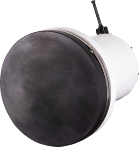
Octans
Surface gyrocompass & motion sensor
Heading accuracy: 0.1 deg RMS
Roll & Pitch accuracy: 0.01 deg RMS
Heave: 5 cm or 5% RMS

Hydrins
High-performance INS for hydrographic and multibeam surveys
Heading accuracy: 0.01 deg RMS
Roll & Pitch accuracy: 0.01 deg RMS
Heave: 5 cm or 5% RMS

Phins Surface
Multipurpose high-performance INS
Heading accuracy: 0.01 deg RMS
Roll & Pitch accuracy: 0.01 deg RMS
Heave: 2.5 cm or 2.5% RMS
Inertial Navigation for ROVs and AUVs
We provide a complete range of Fiber Optic Gyroscope-based high-grade AHRS and subsea INS for remotely operated vehicles (ROVs) and autonomous underwater vehicles (AUVs).
For ROVs

Octans Subsea
Survey-grade gyrocompass and AHRS
Heading accuracy: 0.1 deg RMS
Roll & Pitch accuracy: 0.01 deg RMS
Depth rating: 3000m

Rovins Nano
Compact navigation-grade INS
Heading accuracy: 0.1 deg RMS
Roll & Pitch accuracy: 0.05 deg RMS
Depth rating: 4000m
DVL-aided position accuracy: 0.04 %TD

Rovins
High-accuracy INS for offshore survey and construction
Heading accuracy: 0.04 deg RMS
Roll & Pitch accuracy: 0.01 deg RMS
DVL-aided position accuracy: 0.02 %TD
Depth rating: 3000m

Phins Subsea
High-performance INS for deep-water operations
Heading accuracy: 0.01 deg RMS
Roll & Pitch accuracy: 0.01 deg RMS
Depth rating: 6000m
For AUVs/UUVs

Octans Nano OEM
Highly compact navigation-grade AHRS
Heading dynamic accuracy: 0.5 deg Seclat
Roll & Pitch accuracy: 0.1 deg RMS
Settling time: <5 mins

Phins Compact Series
Scalable range of highly compact INS
Heading accuracy: 0.01 – 0.15 deg
Roll & Pitch accuracy: 0.01 – 0.05 deg
DVL-aided position accuracy: 0.01 – 0.2 %TD (CEP 50)
Inertial Navigation for Land and Aerial Vehicles
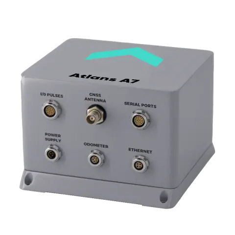
The Atlans Series is a scalable range of INS dedicated to land and air mobile mapping applications. They provide Fiber-Optic gyroscope (FOG) performance for land-based and aerial mapping and surveying platforms (UAVs, UGVs, planes, helicopters). Easy-to-install and operate, the systems deliver high-accuracy positioning even in GNSS-denied environments.
Features and Benefits:
- Simplified integration with all-in-one housing and single GNSS antenna setup
- Predefined vehicle modes: aerial, land, train
- North-finding even in GNSS-denied environment
- Dynamic alignment with GNSS
- INS/GNSS smart coupling
- Compatible with Exail Delph INS post-processing software
- ROS driver available
- 24/7 worldwide technical assistance
- ITAR-free
 |
 |
|
| Model | Atlans A3 | Atlans A7 |
| Heading Accuracy (RTK) | 0.05 deg | 0.015 deg |
| Heading Accuracy (PPK) | 0.035 deg | 0.012 deg |
| Position Drift for land applications (RTK) | 1.5m | 0.4m |
| Position Drift for land applications (PPK) | 0.4m | 0.08m |
INS Post-Processing Software
Delph INS
Post-Processing software for iXblue subsea navigation
Delph INS is the post-processing and batch productivity tool for subsea INS product range (Phins Subsea, Rovins, Rovins Nano and the Phins Compact Series). It provides real-time monitoring and integration of both iXblue navigation systems and other sensors such as GPS, USBLs, LBLs, DVLs and pressure sensors.

Powerful post-processing features include INS/ DVL post-mission calibration, QA/QC reports generation, 2D vehicle trajectory viewing and customizable map projections.
Acoustic Positioning & Communications
Ultra-short baseline USBL Positioning
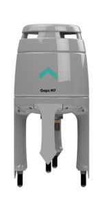
Gaps Series
High-accuracy ultra-sort baseline acoustic positioning systems for medium-depth and deep sea operations

Gaps Series has been designed to provide accurate location, positioning and tracking of subsea assets (ROVs, AUVs…), from ultra-shallow to deep water depths. The Gaps Series embeds a FOG-based subsea motion sensor for vessel positioning redundancy and subsea telemetry. It is compatible with third-party equipment.

Featuring an embedded gyro and a 3D configuration acoustic antenna, both Gaps are omnidirectional and do not need to be oriented. The 200° acoustic aperture allows Gaps Series to track horizontally and operate with nominal accuracy in ultra shallow waters.
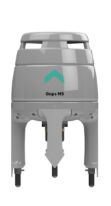 Gaps M5 |
 Gaps M7 |
|
| Absolute accuracy | <0.5% | up to 0.06% |
| Range | 995 m | 4000 m |
| Heading accuracy | 0.5° | 0.01° |
| Roll & pitch accuracy | 0.1° | 0.01° |
| Coverage | 200° | 200° |
Posidonia
Highly accurate and ultra–long range tracking USBL positioning system

Range: 10,000m
Accuracy: 0.1%
Antenna aperture: 70/100deg
Operating frequency: 8 – 18 kHz
LBL Positioning
Long baseline acoustic positioning
Our high-accuracy LBL (Long Baseline) transceivers and transponders can be combined with a subsea INS to provide sparse-LBL navigation, requiring fewer transponders without sacrificing performance.

Ramses
Intelligent transceiver with flexible deployment
Position accuracy: <0.1m
Range precision >0.01m (1 sigma)
Maximum range: 4000m
Depth rating: 6000m

Canopus
Intelligent transponder for seabed or AUV use
Accuracy: < 0.01m
Data telemetry: 500 bps
Depth rating: 4000m
Supervision Software
Delph Subsea Positioning Technology
Delph Subsea Positioning is an integrated software package for intuitive setup, operation and post-processing of iXblue subsea positioning products. Compatible with the full range of our subsea systems, the software features four powerful modules:

LBL Array Planning
Import CAD drawings and sound velocity profiles, arrange transponders and dynamically calculate visibility maps.

Navigation Simulation
Simulate INS/DVL and LBL/Sparse LBL performance, configure sensors and define vehicle trajectories.

Operations
Manage projects, configure equipment, log and display data, and more.

Post-processing
Import and export data, view graphs and maps, and generate QA/QC reports.
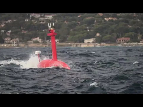
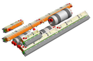
Unmanned Surface Vehicles (USV)
DriX H-8 / H-9 Medium & long range USV
Versatile autonomous surface vessel for optimal data acquisition
With over 10,000 hours in operations around the world over the past three years, Exail’s DriX USV, along with its efficient launch and recovery system, is a seasoned asset in the environment of supervised autonomy.
 Able to conduct both remote-controlled and supervised autonomous operations (within visual range or Over The Horizon), DriX H-8 / H-9 offers outstanding seakeeping and speed capabilities.
It is a versatile and efficient USV that can host a wide range of payloads and that offers optimum conditions for high quality data acquisition in both shallow and deep waters.
DriX O-16 Transoceanic Range USV
Unique speed combination of speed, endurance and payload capabilities
Benefiting from an autonomy of 3,500 Nm and a unique naval architecture that enables the USV to withstand the most severe ocean conditions, the new Drix O-16 has been designed for long-duration operations (up to 30 days) and can deploy multiple payloads and subsea assets.
The new USV leverages the successful track record of the already existing Drix USV launched back in 2017 and that accumulates over 150,000 hours of operations at sea in more than 19 countries.
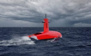 The new Drix O-16 benefits from a hybrid propulsion, redundant architecture, advanced communication systems, as well as Al powered obstacle detection and avoidance capabilities. It offers a high level of reliability and operational efficiency, and new multi-mission capabilities, for enhanced autonomous operations at sea.
| DriX H-8 Medium range |
DriX H-9 Long range |
DriX O-16 Transoceanic range |
|
| Length | 7.71 m | 9 m | 15.75 m |
| Displacement | 1.6 t | 2.1 t | 10.5 t |
| Endurance* | < 10 days | < 20 days | < 30 days |
| Speed | < 14 kts | < 13 kts | < 16 kts |
| Fuel capacity | 250 L | 550 L | 2,300 L (dual hybrid propulsion) |
| Range | 1,000 nm | 2,000 nm | 3,500 nm |
| Communications | Wifi, 4G, Satellite communication, UHF radio | Wifi, 4G, Satellite communication, UHF radio | Wifi, 4G, Satellite communication, UHF radio |
| Tow / launch & recovery | ROTVs towing capabilities | ROTVs towing capabilities | ROTVs, Inspection Class ROVs, 1,000 m rated AUVs |
| Station keeping | Hovering | Hovering | Dynamic Positioning |
| MBES capacity | 3,000 m depth | 3,000 m depth | Full ocean depth |
| Transportation | 1x 40’ High Cube container | 1x 40’ High Cube container | 2x 40’ High Cube container |
| Other | Launch & Recovery system | Customizable stern section for additional payload integration |
Seabed mapping solutions
3D multibeam sonars

SeapiX-R
Volume 3D sonar for fishery research
SeapiX-R is a compact 3D multibeam sonar providing accurate water column coverage, biomass assessment and seabed mapping for fishery, scientific research and marine environmental monitoring. It features a dual Mills Cross multibeam sonar transducer and multiple advanced modulation modes for superior detection performance even under challenging conditions.
- Aperture: 120°x120° angular
- Beam resolution: 1.6° angular
- Frequency: 145 – 155 kHz
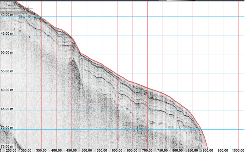
Synthetic Aperture Mapping Sonars
SAMS Series
The SAMS Series of synthetic aperture sonars (SAS), with integrated positioning and navigation capabilities, provides superior georeferenced imaging performance for hydrographic surveying applications. SAMS sonars are available as towfish platforms or as an OEM package for integration into AUVs and ROVs.
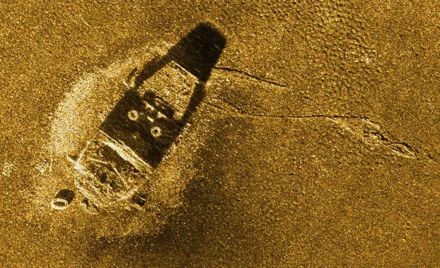
Wreck “Le Corse” in the bay of La Ciotat -– Depth 80m – Range 150m
| Model |  SAMS-150 SAMS-150 |
 SAMS-50 SAMS-50 |
| Central Frequency | 150 kHz | 55 kHz |
| Bandwidth | 30 kHz | 15 kHz |
| Swath | 500m | 1600m |
| Along-track/across-track resolution | 6cm x 2.5cm | 50cm x 5cm |
| Depth | 2 versions: 1000m and 6000m | 6000 m |
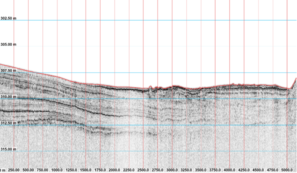
Sub-bottom Profilers
Echoes Series
The Echoes Series of sub-bottom profilers is a complete range of solutions for acquiring, processing and interpreting high-quality geological data. Featuring very low distortion power amplifiers and proprietary transducer design, the compact systems cover a wide frequency spectrum and are ideal for applications such as geosciences, archaeology and offshore energy.
 Echoes Compact Echoes Compact |
 Echoes 5000 Echoes 5000 |
 Echoes 3500 T1 Echoes 3500 T1 |
|
| Frequency (kHz) | 5 – 15 | 1.7 – 8.5 | 1.8 – 6.2 |
| Mean acoustic level (dB ref 1μPa@1m) | 194 | 180 | 195 |
| Transmission power (kVA) | 1 | 1 | 1 |
| Resolution (cm) | 7.5 | 11 | 17 |
| Digital data format (bit raw data) | 24 | 24 | 24 |
| Aperture (°) | 30 | Omnidirectional | 45 |
| Autonomous Platform Compatability | USV | AUV | USV |
Geophysical Software
Delph Sonar
Delph Sonar is a complete acquisition, processing and interpretation software package for side-scan sonar (SSS) surveys. Compatible with most analogue and digital SSS systems, it provides 2D profile view and 3D geographic data visualization as well as batch processing and global QC.

Delph SAS
Delph SAS adds streamlined synthetic aperture sonar processing capabilities to the Delph Sonar software package, seamlessly integrating into the same workflow. Advanced features include accurate absolute real-time positioning, full-resolution INS-based navigation and motion compensation, and robust SAS processing against sonar motion.

Delph Seismic
Delph Seismic is a complete acquisition, processing and interpretation software package for data collected from high-resolution seismic systems and sub-bottom profilers. Featuring 2D profile view and 3D geographic data visualization as well as batch processing and global QC, it provides an intuitive workflow and enhanced efficiency for geologists and geophysicists.

Delph Roadmap
Delph RoadMap provides advanced real-time and offline data display for all Delph software packages in a powerful 2D/3D cartographic environment. Supporting almost all geodetic systems, it can connect to single or multiple positioning sensor setups, providing easy project organization.

Delph Mag
Delph Mag generates accurate 2D and 3D magnetic anomaly maps for the location and mapping of magnetic sources and buried objects. It can be used as part of a combined multi-sensor interpretation solution along with side-scan sonar, sub-bottom and bathymetry data.

Solutions for Naval Defense Applications
We develop military-grade navigation, positioning and imaging solutions for naval defense forces, providing exceptional accuracy and performance for critical missions and for all kind of platforms.
Inertial Navigation Solutions
With products in service with over 40 navies worldwide, we are the European leader in inertial systems for naval defense. We have developed a wide range of inertial navigation solutions for the full spectrum of naval applications, including both manned and unmanned surface and subsea vessels of all sizes.
Marins Series
Military Strategic Grade INS
The Marins Series is a family of state-of-the-art strategic-grade FOG inertial navigation systems, designed to meet highly demanding naval performance requirements. They are ideal for stealth autonomous navigation for submarines and unmanned underwater vehicles, as well as surface vessels operating in GNSS-denied environments.
| M3 | M5 | M7 | M8 | M9 | M11 | |
| Position accuracy | 1/12 nm/h | 1/24 nm/h | 1/72 nm/h | 1/96 nm/h | 1/120 nm/h | 1/360 nm/h |
| Velocity (RMS) | 0.6 knots | 0.6 knots | 0.4 knots | 0.4 knots | 0.4 knots | 0.4 knots |
| Heading accuracy | 0.01 deg | 0.01 deg | 0.01 deg | 0.01 deg | 0.01 deg | 0.01 deg |
| Roll & Pitch accuracy | 0.01 deg | 0.01 deg | 0.01 deg | 0.01 deg | 0.01 deg | 0.01 deg |
Phins Surface
High-performance surface INS
Heading accuracy: 0.01 deg RMS
Roll & Pitch accuracy: 0.01 deg RMS
Heave: 2.5 cm or 2.5% RMS

Octans
All-in-one AHRS for high-speed vessels
Heading accuracy: 0.1 deg RMS
Roll & Pitch accuracy: 0.01 deg RMS
Heave: 5 cm or 5% RMS
Quadrans
Compact FOG AHRS for demanding navigation requirements
Heading accuracy: 0.23 deg RMS
Roll & Pitch accuracy: 0.1 deg RMS
Settling time: <30 min
Phins Compact Series
Scalable and compact subsea INS for all types of AUVs
Heading accuracy: 0.01 – 0.15 deg
Roll & Pitch accuracy: 0.01 – 0.05 deg
DVL-aided position accuracy: 0.01 – 0.2 %TD (CEP 50)
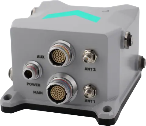
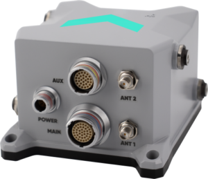
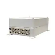
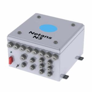
Navigation Data Distribution & Computation System (NDDCS)
Netans Series
Navigation data distribution systems
The Netans Series of Navigation Data Distribution & Computation System (NDDCS) provides a centralised control and processing unit for all navigation sensor data on board a vessel, acting as a consistent common reference system. Providing data validity, integrity and coherence, Netans NDDCS also feature sophisticated cyber-attack protection.
")
 |
 |
 |
 |
|
| Model | Netans N1 | Netans N3 | Netans N5 | Netans N7 |
| Ethernet Ports | 2 | 6 | 24 | 48 |
| I/O Modules | 2 | 6 | 11 | 22 |
| Time Clock | External | External | Optional | Optional |
| UPS | External | External | Included | Included |
Warship Electronic Chart Display and Information System (WECDIS)
The Gecdis-W Warship Electronic Chart Display and Information System provides an intuitive interface for naval fleet navigation and route planning, submarine collision avoidance, weapons coverage and more. The system provides data fusion for integration of bathymetric, radar, optronic and other sensors.

Subsea Positioning Technology

Gaps M5
High-accuracy medium-depth USBL for AUVs and divers tracking
Absolute accuracy: <0.5%
Range: 995 m
Heading accuracy: 0.5 deg
Roll & pitch accuracy: 0.1 deg

Gaps M7
High-accuracy deep-sea USBL tracking for AUVs and mine counter-measures
Absolute accuracy: up to 0.06%
Range: 4000 m
Heading accuracy: 0.01 deg
Roll & pitch accuracy: 0.01 deg
Forward Looking Sonar (FLS)
The FLS Series is a 3D multi-beam Forward Looking Sonar designed for obstacle avoidance from the surface to the seabed. Two versions are available: the compact FSL150 for smaller ships and USVs, and the FLS 60 for larger vessels and unmanned underwater vehicles.

 |
 |
|
| Detection ranges | FLS 150 | FLS 60 |
| Anchored targets (-15 DB) | >330m | >650m |
| Drifting targets (-15 DB) | >330m | >350m |
| Bottom targets (-15 DB) | >300m | >350m |
| Low TS targets (-25 DB) | >250m | >520m |
Unmanned Surface Vehicles
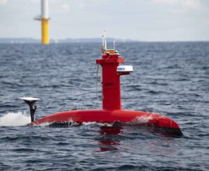
DriX
Long-Endurance Autonomous Surface Vessel
DriX is a multi-mission long-endurance ASV that brings agility, innovation and disruptiveness to a wide range of coastal and offshore hydrographic missions.
Featuring both manual and autonomous operation, it can be equipped with a variety of payloads, including towed-array and side-scan sonars, USBLs, LiDAR and optical sensors.
- Length: 7.7m
- Displacement: 1.4 tons
- Endurance: Up to 7 days
- Maximum speed: > 10 knots

Solutions for Land Defense
Our military-grade navigation and positioning solutions ensure continuous and reliable operation in land defense and security applications.
Inertial Navigation Solutions
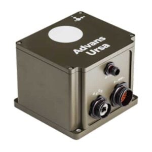
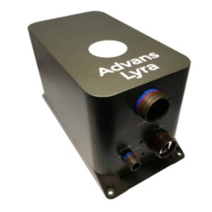
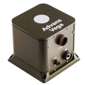
Advans Series
Our ITAR-free Advans Series of inertial navigation systems provide high-accuracy continuous positioning, heading and attitude information for UGV and land robotics applications such as tactical navigation and weapons systems pointing.


All variants are based on the same architecture and software, are adaptable to a wide range of communication protocols and feature an intuitive web-based user interface.
 |
 |
 |
|
| Ursa U5 | Lyra L7 | Vega | |
| Horizontal position accuracy (no GNSS) | 0.4% DT | 0.2% DT | 0.1% DT |
| Heading accuracy | 4 mils | 1 mils | 0.5 mils |
| Roll & pitch accuracy | 1 mils | 0.5 mils | 0.2 mils |